


 As digital transformation becomes a new driver of development, Vietnamese researchers have proposed a planning information system model that applies Geographic Information Systems (GIS) and artificial intelligence (AI) in Vinh Long Province. The research contributes to modernizing planning administration while introducing a new approach to digital government and data-driven governance in Viet Nam.
Digital data as the foundation of planning governance
In the era of digital transformation, data is increasingly recognized as a strategic resource for nations. In planning administration, managing thousands of maps, records, and documents across multiple sectors remains a major challenge for public administrative agencies. Ensuring that planning data is interconnected, synchronously updated, easily searchable, and effectively accessible to citizens and businesses has become an urgent requirement in the development of digital government.
In Viet Nam, researchers are gradually addressing this challenge by applying geospatial technologies (GIS), digital databases, and artificial intelligence (AI) to planning administration. This effort is reflected in the research project titled “Design of a GIS-Based planning information system for digital transformation in Vinh Long province.”
The study was conducted by a team of researchers including Nguyen Xuan Linh, Pham Le Tuan, Bui Ngoc Tu, and Dong Vu Ha from VNU University of Science, Viet Nam National University, Hanoi, together with Dang Trung Tu from the Institute of Strategy and Policy on Agriculture and Environment. The research represents an interdisciplinary collaboration among geospatial technology, data science, and policy analysis, aimed at developing a modern planning administration model grounded in digital data.
More than a purely technical study, the research reflects a broader transformation in Viet Nam’s development governance model, in which data is increasingly becoming the foundation for policymaking, resource management, and spatial development planning.
GIS as a foundation for modern spatial governance
Globally, Geographic Information Systems (GIS) have become essential tools in urban management, spatial planning, transportation, environmental management, and natural resource governance. This technology enables the integration of spatial data with sector-specific information layers, creating strong capabilities for analysis, visualization, and evidence-based decision-making.
In Viet Nam, digital transformation is creating new opportunities for local governments to modernize planning administration systems. However, in practice, much planning-related data remains fragmented, stored across multiple agencies, or maintained in paper-based records, creating substantial barriers to data access and information sharing.
In response to this reality, the research team proposed the development of a GIS-based planning information system for Vinh Long Province. The system is designed to integrate data layers related to land-use planning, technical infrastructure, transportation, environment and natural resources, and associated legal documents into a unified database.
Data standardization and integration not only reduce information fragmentation but also provide a foundation for more effective inter-agency coordination in planning formulation and implementation.
From digital databases to public service delivery
A key strength of this research lies not merely in digitizing maps, but in developing a planning information system capable of directly serving both administrative management and the information needs of society.
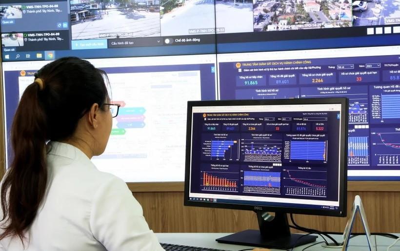
According to the system design proposed by the authors, the WebGIS platform enables users to access data online and search for information by geographic location, administrative unit, or area of interest. Data layers can be displayed flexibly, allowing users to easily monitor current conditions and spatial development directions for specific areas.
The system is also linked to legal documents, planning records, and technical reference materials, creating an integrated data environment instead of the fragmented document-based search processes commonly used in the past.
For citizens and businesses, this means faster, more transparent, and more convenient access to planning information. For government agencies, it provides a powerful tool to support monitoring, updating, and supervising planning implementation.
As demands for public information disclosure continue to increase, the development of open planning data systems is also regarded as a critical solution for strengthening transparency in public administration.
Integrating AI into planning governance
One of the most notable innovations of the study is the proposed integration of artificial intelligence into the planning information system.
According to the research team, the AI component is developed using a retrieval-augmented generation (RAG) architecture—a technology increasingly adopted by advanced knowledge systems worldwide. Rather than generating responses solely from generalized training data, the system first retrieves relevant planning documents, spatial databases, and related materials before synthesizing a response for the user.
As a result, citizens or government officials can directly ask planning-related questions and receive answers accompanied by specific reference sources.
This represents a significant advancement in applying AI to public governance, as transparency and source traceability are essential requirements in planning and public administration.
If implemented at scale, this model could significantly reduce information processing time, improve public service quality, and support faster and more accurate decision-making by government agencies.
Toward data-driven governance
Beyond serving as a search platform, the system is also designed as a tool for planning administration and monitoring. Through spatial analysis functions, administrative agencies can assess the alignment between current development conditions and approved planning frameworks, monitor changes in development zones, and generate area-based statistics by land-use category or administrative unit.
Real-time data analytics enhances monitoring effectiveness and supports future adjustments to development policies. As Viet Nam accelerates the development of digital government, digital administration, and the digital economy, such data-driven information systems are increasingly seen as foundational to improving national governance quality.
For Vinh Long Province, this research not only addresses local digital transformation requirements but also has the potential to serve as a reference model for other provinces and cities seeking to modernize planning administration.
Vietnamese innovation in the data era
Globally, the application of GIS in planning administration is no longer new. However, the greatest challenges continue to lie in data integration, cross-sector information sharing, and translating technological capabilities into practical services for citizens.
The research conducted by scholars from VNU University of Science and the Institute of Strategy and Policy on Agriculture and Environment demonstrates that Vietnamese scientists are actively engaging with cutting-edge global technological trends while adapting them to domestic institutional and practical conditions.
Beyond a single research project, this work illustrates that digital transformation in Viet Nam is not merely a matter of investing in technological infrastructure. It is also a process of transforming governance models and leveraging data to support sustainable development.
At a time when data is increasingly viewed as a strategic resource of the twenty-first century, research of this kind reinforces the role of Vietnamese science and technology in advancing digital government, smart cities, and modern governance systems.
By transforming spatial data into actionable planning tools, Vietnamese researchers are helping establish new foundations for development management. This reflects not only technological innovation but also Viet Nam’s proactive efforts to leverage data in building governance systems that are more transparent, effective, and citizen-centered.

Using waste ethylene-vinyl acetate (EVA) shoe soles and vulcanized rubber—materials traditionally considered difficult to recycle—a research team from the School of Materials Science and Engineering at Hanoi University of Science and Technology has successfully developed a fully recycled composite material, creating potential new applications in green manufacturing and sustainable industrial production. The study not only contributes to addressing industrial waste challenges but also highlights Vietnam’s growing research and innovation capacity in sustainable materials and the circular economy.

The research project entitled “Development of a suitability map for Arabica coffee cultivation on sloping land in Dien Bien province using remote sensing data, GIS technology, and the analytic hierarchy process (AHP)” conducted by Dinh Xuan Hung, Bui Tuan Hai, and Nguyen Ngoc Sang of the Institute of Water Resources Planning represents a scientifically and practically significant study in the context of ongoing agricultural restructuring toward sustainable production systems that are better adapted to natural conditions and capable of utilizing land resources more efficiently in Viet Nam’s Northern midlands and mountainous region.

Intensive shrimp farming generates substantial economic benefits but also exerts increasing pressure on aquatic environments, particularly through wastewater rich in organic matter and toxic byproducts generated during farming operations. In the context where many shrimp farms still lack appropriate wastewater treatment systems, a research team from Can Tho University and Toan Viet Technological Environment Company Limited conducted an experimental study to assess the potential use of fishing nets—a readily available, low-cost material—as a filter material for biological treatment of wastewater from intensive shrimp ponds.
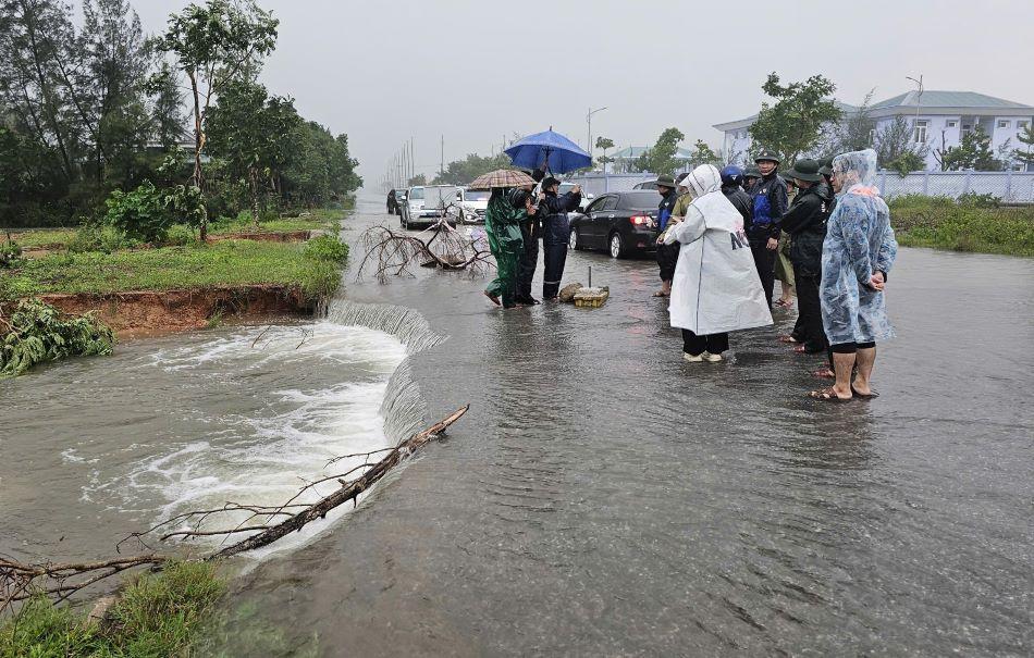
As floods become increasingly complex and extreme in Viet Nam’s North Central region, the demand for an early warning system that is reliable, fast to operate, and suitable for local-level application has become more urgent than ever. A research team from the Vietnam Academy for Water Resources—including Nguyen Thanh Hung, Vu Dinh Cuong, Trieu Quang Quan, and Nguyen Anh Hung—has developed an integrated technological solution that combines flood and inundation forecasting with modern communication tools. The study aims not only to enhance forecasting capacity but also to ensure that warning information reaches the right people at the right time under emergency flood conditions.

The use of pesticides is an integral part of modern intensive agriculture. Alongside their effectiveness in controlling pests and diseases, however, comes the risk of environmental pollution from wastewater generated during the production, formulation, and application of chemical active ingredients. Of particular concern is the fact that many pesticide compounds are poorly biodegradable, persistent in the environment, and prone to bioaccumulation, posing major challenges for wastewater treatment.