


 As floods become increasingly complex and extreme in Viet Nam’s North Central region, the demand for an early warning system that is reliable, fast to operate, and suitable for local-level application has become more urgent than ever. A research team from the Vietnam Academy for Water Resources—including Nguyen Thanh Hung, Vu Dinh Cuong, Trieu Quang Quan, and Nguyen Anh Hung—has developed an integrated technological solution that combines flood and inundation forecasting with modern communication tools. The study aims not only to enhance forecasting capacity but also to ensure that warning information reaches the right people at the right time under emergency flood conditions.
Current status of flood forecasting and early warning in Quang Tri
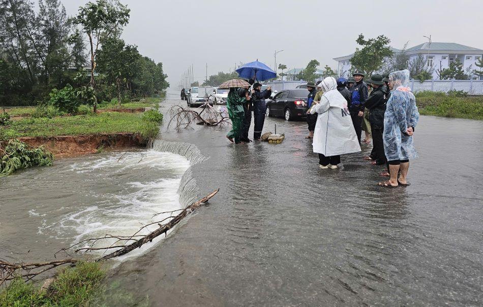
Quang Tri province is located in the North Central region of Viet Nam, an area frequently and directly affected by tropical storms, tropical depressions, cold surges, and the intertropical convergence zone. Its steep terrain, short river basins, and dense river network—dominated by three main river systems (Ben Hai, Thach Han, and O Lau)—cause floods to form rapidly, with large water-level fluctuations and short flood propagation times. These characteristics significantly increase the risk of widespread downstream inundation, particularly when heavy rainfall coincides with unfavorable tidal conditions at river estuaries.
In recent years, flood forecasting and early warning activities in Quang Tri have seen certain improvements through the application of hydrological–hydraulic models and support from domestic and international programs and projects. However, from an operational disaster risk management perspective at the local level, several systemic limitations remain. Mathematical models can produce relatively accurate results when sufficient input data are available and well calibrated, but they often require long computation times and operators with advanced technical expertise. These requirements are difficult to meet during rapidly evolving flood events, when warnings must be issued within a very short time frame.
In addition, local capacity to operate forecasting models is constrained by limited specialized human resources and computational infrastructure. During flood events, the transmission of warning information from disaster management authorities to grassroots administrations and affected communities also faces many challenges, particularly under conditions of power outages and disrupted communications. Traditional channels such as television, radio, or loudspeakers do not always effectively reach vulnerable groups.
These constraints indicate that, for Quang Tri Province, the challenge lies not only in improving flood forecast accuracy but also in developing an early flood and inundation warning system that can operate quickly, match real-world operational conditions, and ensure timely delivery of warning information to communities.
From practical needs to a new forecasting approach
Based on the current situation of flood forecasting and early warning in Quang Tri, the research team from the Vietnam Academy for Water Resources adopted an approach focused on addressing two core limitations of conventional forecasting models in disaster risk management applications: long computation times and high operational skill requirements. Instead of running models in real time for each specific flood event, the study proposes pre-calculating a range of possible flood and inundation scenarios, allowing prepared results to be rapidly utilized when new forecast inputs become available.
Through analysis of long-term hydro-meteorological data and major weather patterns causing heavy rainfall in Quang Tri, the study developed a set of representative flood and inundation scenarios combining rainfall conditions, reservoir operation schemes, river water levels, and estuarine tidal conditions. In total, 282 flood and inundation scenarios were simulated using integrated hydrological, hydraulic, and inundation models, forming a scenario database to support early warning activities.
A key element of this approach is the application of a decision tree algorithm to interpolate inundation results from the pre-calculated scenario library when new forecast data—such as rainfall, river water levels, reservoir operation status, and estuarine tides—become available. This enables the system to generate inundation extent and depth information almost instantaneously, meeting the time-critical requirements of disaster risk management while reducing reliance on advanced modeling expertise at the local level.
This approach creates a close linkage between the scientific foundation of mathematical models and the practical needs of flood and inundation early warning. It also provides the basis for further development of forecasting and communication components, contributing to the establishment of an early flood and inundation warning system suitable for Quang Tri Province and transferable to areas with similar conditions.
An integrated flood and inundation forecasting system for Quang Tri and adjacent areas
Building on the defined approach, the research team developed an integrated flood and inundation forecasting system covering Quang Tri Province and neighboring areas, including major river basins and downstream zones directly affected by flooding. The system combines hydrological modeling, reservoir operation modeling, hydraulic modeling, and inundation modeling to comprehensively represent flood generation, propagation, and inundation processes from upstream catchments to estuaries and coastal areas.
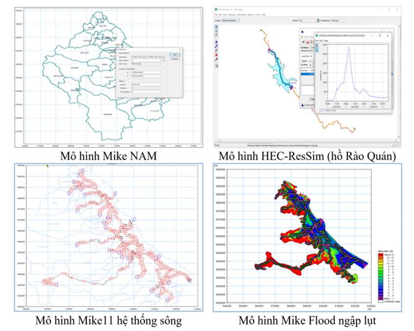
Specifically, the MIKE NAM hydrological model was applied to simulate rainfall–runoff processes for river basins in Quang Tri and surrounding regions, with 38 sub-basins delineated and calibrated. The HEC-ResSim reservoir operation model was established for seven reservoirs with flood regulation functions—Rao Quan, Kinh Mon, Bao Dai, La Nga, Ha Thuong, Truc Kinh, and Ai Tu—allowing simulation of the impacts of different reservoir operation scenarios on downstream flooding. Flood propagation along river systems and large-scale inundation were simulated using the combined MIKE 11 and MIKE Flood models, incorporating the effects of tides and storm surges at river mouths.
Using this modeling framework, the study simulated 282 flood and inundation scenarios representing various combinations of rainfall-inducing weather patterns, reservoir operation conditions, and tidal states. Simulation outputs include essential early warning information such as inundation extent, inundation depth, and potentially affected areas and infrastructure. All results were standardized and stored in a database, forming a flood and inundation scenario library that serves as the core of the early warning system.
By pre-calculating scenarios and their corresponding outputs, the system shifts its focus from “real-time computation during flood events” to “rapid utilization of available results,” significantly reducing the time required to issue forecasts. This feature is particularly critical in disaster risk management operations, where speed and timeliness of warnings are often decisive factors.
Integrating communication technology into the early warning system
In addition to forecasting components, the study identifies warning communication as an indispensable element of an effective early flood and inundation warning system. In practice, even reliable forecasts have limited value if warning information is not transmitted promptly and accessibly to local authorities and affected communities.
To address this challenge, the research team developed web-based communication solutions to visualize and disseminate flood and inundation warning information in a flexible and user-friendly manner. A WebGIS-based system was established to integrate forecast data, inundation maps, and related information layers, enabling users to monitor flood developments in space and time without the need for specialized software installation.
Given the increasing penetration of smartphones and mobile internet in Viet Nam, mobile web applications were also developed using responsive web design to ensure compatibility across different devices and screen sizes. Push notification functions were integrated to allow warning messages to be transmitted directly from the WebGIS system to end users within a short time frame.
This approach helps overcome the limitations of traditional communication channels under severe flood conditions, when power outages and communication disruptions are common. Through web-based platforms and mobile devices, flood and inundation warning information can reach a wider audience—particularly populations living in deeply inundated areas—thereby supporting proactive response and reducing disaster-related losses.
Implications for disaster risk management practice
The study on flood forecasting and communication technology for Quang Tri province and neighboring areas demonstrates an approach well aligned with the practical requirements of local-level disaster risk management. Rather than emphasizing increasingly complex modeling systems, the research focuses on operational efficiency under time pressure and resource constraints, helping to narrow the gap between scientific research outputs and real-world disaster response needs.
From an applied science perspective, the study integrates proven hydrological and hydraulic models with scenario-based data organization and a decision tree algorithm to enable rapid interpolation of inundation results for early warning purposes. This approach does not alter the physical principles of flood simulation but provides a more flexible and timely mechanism for using modeling results, particularly in rapidly evolving flood situations.
In practical terms, the developed system reduces dependence on advanced modeling capacity at the local level while shortening the time required to deliver flood and inundation forecasts and warnings. The integration of communication components through WebGIS platforms and mobile applications enhances access to warning information for both local authorities and at-risk communities, supporting informed decision-making and evacuation when necessary.
With these characteristics, the research holds significance not only for Quang Tri Province but also for other provinces in Viet Nam’s central region with similar natural conditions and flood regimes. To ensure long-term effectiveness, however, regular updates of the database and recalibration of flood scenarios in response to changes in terrain, infrastructure, and climate conditions will be essential during system operation.
In the context of climate change, which is increasing the frequency and intensity of extreme flood events, this study provides an additional scientific and practical basis for improving early flood and inundation warning systems in Viet Nam, contributing to enhanced disaster preparedness and reduced risks for communities.

As digital transformation becomes a new driver of development, Vietnamese researchers have proposed a planning information system model that applies Geographic Information Systems (GIS) and artificial intelligence (AI) in Vinh Long Province. The research contributes to modernizing planning administration while introducing a new approach to digital government and data-driven governance in Viet Nam.

Using waste ethylene-vinyl acetate (EVA) shoe soles and vulcanized rubber—materials traditionally considered difficult to recycle—a research team from the School of Materials Science and Engineering at Hanoi University of Science and Technology has successfully developed a fully recycled composite material, creating potential new applications in green manufacturing and sustainable industrial production. The study not only contributes to addressing industrial waste challenges but also highlights Vietnam’s growing research and innovation capacity in sustainable materials and the circular economy.

The research project entitled “Development of a suitability map for Arabica coffee cultivation on sloping land in Dien Bien province using remote sensing data, GIS technology, and the analytic hierarchy process (AHP)” conducted by Dinh Xuan Hung, Bui Tuan Hai, and Nguyen Ngoc Sang of the Institute of Water Resources Planning represents a scientifically and practically significant study in the context of ongoing agricultural restructuring toward sustainable production systems that are better adapted to natural conditions and capable of utilizing land resources more efficiently in Viet Nam’s Northern midlands and mountainous region.

Intensive shrimp farming generates substantial economic benefits but also exerts increasing pressure on aquatic environments, particularly through wastewater rich in organic matter and toxic byproducts generated during farming operations. In the context where many shrimp farms still lack appropriate wastewater treatment systems, a research team from Can Tho University and Toan Viet Technological Environment Company Limited conducted an experimental study to assess the potential use of fishing nets—a readily available, low-cost material—as a filter material for biological treatment of wastewater from intensive shrimp ponds.

The use of pesticides is an integral part of modern intensive agriculture. Alongside their effectiveness in controlling pests and diseases, however, comes the risk of environmental pollution from wastewater generated during the production, formulation, and application of chemical active ingredients. Of particular concern is the fact that many pesticide compounds are poorly biodegradable, persistent in the environment, and prone to bioaccumulation, posing major challenges for wastewater treatment.