




 As countries around the world accelerate data-driven marine governance, Viet Nam is gradually building an integrated and modern marine data platform to support marine resource management, marine environmental protection, and the sustainable development of the marine economy.
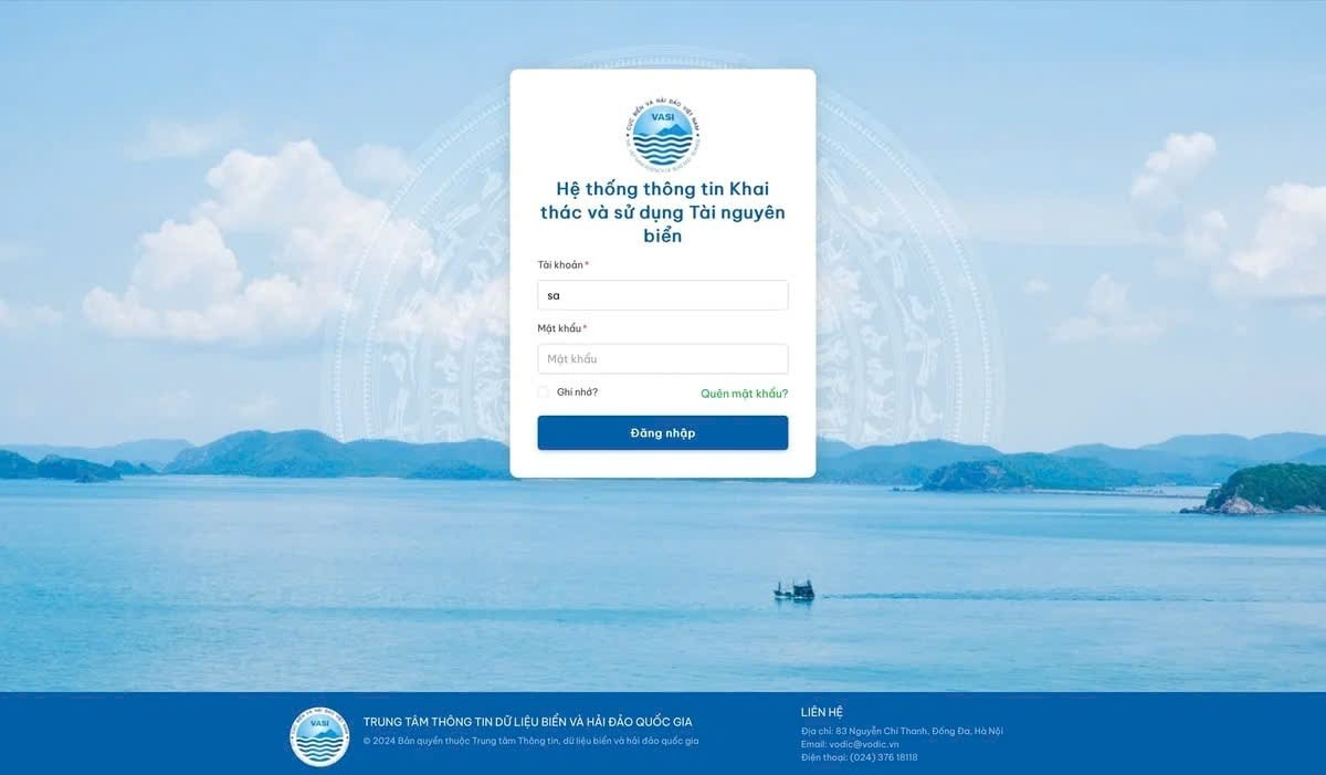
A major milestone in this process was the nationwide launch of the Marine Resource Exploitation and Use Information System at the end of March 2026. The system is considered a significant step forward in the digital transformation of Vietnam’s seas and islands sector, helping connect interoperable data from central to local levels while improving transparency and the effectiveness of state management over marine space.
According to the Viet Nam Agency of Seas and Islands, the system has now been deployed uniformly across all 21 coastal provinces and centrally run cities in Viet Nam. Data are being updated, standardized, and synchronized with the national data center to build a database that is “accurate, sufficient, clean and live,” ensuring long-term accuracy, interoperability, and usability.
One of the system’s key features is its ability to integrate 54 reference data layers related to marine space. These include the national marine spatial plan, coastal zone planning, sea dumping plans, sectoral and regional plans, administrative base maps, marine topography, maritime boundary lines, and data on allocated marine areas.
The digitization and integration of these data layers allow management agencies to access information in real time, supporting science-based decision-making instead of the previously fragmented management approach.
Experts said the development marked an important step toward a modern marine governance system aligned with international trends, in which digital data play a central role in marine resource management, environmental monitoring, and policymaking for the sustainable marine economy.
Beyond data storage, the system also provides statistical tools, multidimensional analysis, and data visualization functions. Reports are designed for different management levels, from local authorities to national agencies, clearly reflecting the allocation of marine areas, usage scale, geographic distribution, and purposes of marine resource exploitation.
Notably, the system enables data comparisons among localities down to commune and ward levels. The feature is expected to improve transparency in marine resource management and provide a basis for assessing the effectiveness of resource use in each area.
Another highly regarded feature is the system’s interoperability with national databases and online public service platforms. Registration records for marine area allocation are updated in real time, helping maintain “live” data while minimizing duplication and inconsistencies.
The system has also been decentralized to the commune level, enabling local authorities to proactively enter, manage, and monitor records directly at the grassroots level. According to specialists, the approach reflects an open-data and decentralized governance model increasingly adopted by countries in natural resources and environmental management.
In terms of technical infrastructure, the system meets Level 3 information security standards, applies OTP-based user authentication, and includes a mobile version to improve accessibility and operational flexibility for local management officials.
After a short period of operation, the system has already produced initial results. As of March 31, 2026, more than 300 user accounts had been issued down to the commune level and were operating regularly. A total of 1,364 records had been updated, including applications from 256 organizations and 938 individuals for marine area allocation. All information was verified through tax identification numbers and citizen identification cards.
According to Vo Xuan Hung, Director of the National Center for Marine and Island Information and Data under the Viet Nam Agency of Seas and Islands, which directly manages and operates the system, Viet Nam will continue improving the platform’s functions based on practical needs while strengthening local training, upgrading technical infrastructure, and standardizing data to meet large-scale data-processing requirements.
The system will also be further integrated with the national public service platform to ensure that the entire process, from application submission to processing, can be carried out fully in the digital environment. The move is regarded as an important step toward building a digital administration system in the marine natural resources and environment sector.
As the world faces growing challenges related to climate change, marine ecosystem degradation, and unsustainable resource exploitation, data-driven marine management is increasingly viewed as an inevitable trend.
According to international experts, marine data are not only a management tool but also a strategic foundation for countries to strengthen ocean governance capacity, develop a sustainable blue economy, and ensure long-term marine environmental security.
Viet Nam’s development and operation of the Marine Resource Exploitation and Use Information System demonstrate the country’s efforts to adopt a modern, transparent, and science-based marine governance model.
The initiative represents not only a technological advancement but also Viet Nam’s broader shift toward digitalized, interoperable, and multi-sector marine resource management in line with global trends in sustainable ocean governance.

The Environmental Protection Law 2020 took effect from the beginning of 2022, ushering in new policies for biodiversity conservation. The government has issued Decision 149/QĐ-TTg approving the National Strategy on Biodiversity to 2030, with a vision to 2050. These are crucial legal foundations to enhance the effective management of biodiversity resources, including efforts to communication about the protecting wild birds from extinction.

In a significant move for environmental conservation, EU environment ministers approved the Nature Restoration Law, aimed at reversing biodiversity loss across Europe. The law mandates the restoration of at least 20% of the EU's degraded land and sea areas by 2030 and sets progressive targets extending to 2050.

A study warns of a catastrophic global decline in migratory fish populations, which have plummeted by over 80% since 1970. This dramatic drop, primarily due to dams, mining, water diversion, pollution, and habitat loss, threatens both humans and ecosystems. The findings call for stronger monitoring and enhanced efforts in river protection and restoration.

Rising temperatures have made Venezuela the first country in modern history to lose all its glaciers. By 2011, five glaciers had vanished, leaving only the Humboldt glacier, also known as La Corona, in the Sierra Nevada National Park. This final glacier has now melted so significantly that scientists have reclassified it as an ice field.

The British Cave Research Association (BCRA), in collaboration with the Phong Nha-Ke Bang National Park's Management Board, has announced the discovery of 22 new caves in Quang Binh province, central Vietnam.