


 In the context of accelerating climate change, sea-level rise, and increasingly severe coastal erosion in the Mekong Delta, field-based scientific evidence on the coastal protection functions of mangrove forests (MF) has become critically important for shoreline planning and management. Recently, a research team comprising Ly Trung Nguyen, Danh Tinh, and Le Thanh Khang from the College of the Environment and Natural Resources, Can Tho University, completed a large-scale field study in coastal mangrove forests located in the former Soc Trang province, now administratively part of Can Tho city.
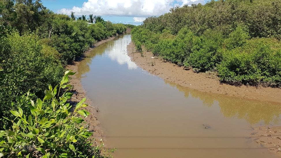
The study provides clear quantitative evidence, for the first time, through simultaneous field measurements of wave attenuation and sediment deposition under two contrasting ecological conditions of mangrove forests: the forest edge and a location 50 m inside the forest. The results offer robust experimental data on the relationship between mangrove forest structure and its ecological functions, contributing directly to coastal protection planning in the Mekong Delta.
Research background and scientific rationale
Mangrove forests are intertidal ecosystems located at the interface between land and sea, functioning as natural buffer zones that absorb wave energy, reduce coastal erosion, and stabilize shorelines. Numerous international studies have demonstrated that mangroves attenuate wave dynamics, trap suspended sediments, and promote natural accretion processes. However, in Vietnam—particularly in the coastal areas of Soc Trang and Can Tho—field-based studies supported by detailed instrumental measurements remain limited.
The Mekong Delta is currently facing multiple challenges, including widespread shoreline erosion, land subsidence, sea-level rise, altered hydrological regimes driven by climate change, and upstream anthropogenic impacts. In this context, mangrove forests, characterized by low maintenance costs, high ecological value, and strong natural regeneration capacity, are increasingly regarded as a more effective solution than hard-engineering structures such as seawalls and coastal dikes. Nevertheless, coastal managers and policymakers require reliable experimental data to support decisions on mangrove conservation, restoration, and coastal zone planning. This scientific gap underscores the necessity and practical relevance of the present study.
Methodology: Integrated field measurements of waves, sediment deposition, and mangrove forest structure
study area
The study was conducted in the coastal zone of the former Soc Trang province, now within the administrative boundaries of Can Tho City. This area contains the largest stands of Sonneratia caseolaris in Viet Nam. Between 2016 and 2022, mangrove forest area showed an increasing trend, contributing to improved coastal protection capacity, although the region continues to experience strong erosion pressures and sediment dynamics.
Experimental design: Two monitoring locations were established:
M1 – Forest edge: characterized by lower tree density, with larger average tree height and trunk diameter.
M2 – Inside the forest (50 m from the forest edge): characterized by significantly higher tree and root density.
At each location, the following measurements were conducted:
- Mangrove forest structure survey: Mangrove structure was surveyed within standard plots (SP) of 100 m² (10 × 10 m) using manual measurement methods. Parameters included tree height, trunk diameter, basal diameter, tree density, and root density. Trunk diameter was measured at 1.3 m above ground (DBH) using a measuring tape. Root height and root abundance were recorded within 1 m² subplots, with measurements repeated three times for each SP. Ground elevation was determined manually using the water tube leveling method.
- Wave measurements: Pressure sensors were installed to continuously record wave characteristics over semi-diurnal tidal cycles typical of the East Sea.
- Sediment deposition sampling: Sediment collectors made of PVC tubes (9 cm in diameter) were installed in a 360-degree configuration and fixed in place for 24 hours to collect deposited sediment.
Laboratory analysis:
Sediment samples were oven-dried at 105°C for 24 hours to determine sediment mass.
The simultaneous measurement of wave dynamics, sediment deposition, and mangrove forest structure produced an integrated and reliable dataset reflecting the functional relationship between MF structure and coastal protection processes.
Wave attenuation within mangrove forests
Results from the two monitoring sites revealed pronounced differences in wave energy. At the location inside the forest (M2), wave energy was consistently lower than at the forest edge (M1). Wave energy decreased by 19–39%, depending on water depth conditions (shallow, intermediate, and deep). Linear regression analyses yielded slopes consistently lower than one, confirming progressive wave attenuation as waves propagated through the mangrove forest structure.
Although trees at the forest edge exhibited larger average trunk diameters (25.57 cm compared to 8.5 cm), tree density inside the forest was three times higher (9 trees per SP compared to 3 trees per SP). This finding demonstrates that vegetation density plays a more critical role than individual tree size in wave attenuation.
Root density was also higher at M2 (52 roots/m² compared to 41 roots/m²), forming a dense below-ground structure that strongly obstructed flow and enhanced wave energy dissipation within the forest.
Sediment deposition enhanced inside dense mangrove forests
Sediment deposition serves as a key indicator of mangrove ecosystem performance in maintaining and expanding intertidal flats. The results showed that:
- At the forest edge, average sediment deposition reached 29.05 g per 24 hours.
- At 50 m inside the forest, sediment deposition increased to 39.53 g per 24 hours, representing a 36.07% increase compared to the forest edge.
Directional analysis further indicated that sediment distribution varied with orientation. At the forest edge, the northwest direction exhibited the highest sediment accumulation, while inside the forest, the southeast direction dominated. This pattern corresponds with established sediment transport dynamics along the Soc Trang–Can Tho coastline, where sediment movement predominantly follows a northwest–southeast trajectory. These results indicate that mangrove forests not only retain sediment but also regulate its spatial distribution along the coast.
Relationship between wave attenuation and sediment deposition
Correlation analysis demonstrated a strong relationship between wave attenuation and sediment deposition: greater reductions in wave energy were associated with higher sediment accumulation. This finding aligns with sediment dynamics theory, whereby reduced wave energy leads to lower flow velocities, facilitating the transition of suspended particles from transport to deposition.
At the forest edge, low tree density resulted in limited wave attenuation and higher flow velocities, constraining sediment deposition. In contrast, inside the forest, high tree and root density reduced wave energy by 19–39%, created calmer hydrodynamic conditions, and enhanced sediment deposition. Through this mechanism, mangrove forests function as natural sediment traps, continuously reinforcing the substrate and contributing to long-term coastal stability.
Scientific and practical implications
The study provides several important contributions to mangrove conservation and coastal management in Vietnam: It offers rare quantitative field-based evidence of wave attenuation by mangrove forests in the Mekong Delta.
It supplies scientific parameters to support the design of coastal protection mangrove belts, including optimal forest width, species selection, and planting density.
It reinforces the role of mangrove expansion as an effective form of green infrastructure, outperforming hard-engineering solutions in terms of sustainability, resilience, and ecological co-benefits.
It establishes a foundation for further research on sediment dynamics, nearshore currents, and the resilience of degraded mangrove systems.
Mangrove forests as a sustainable ecological solution for the Mekong Delta
Based on field measurements, the study concludes that mangrove forests reduce wave energy by 19–39% over a 50 m forest transect and increase sediment deposition by 36.07% compared to forest edge conditions. Mangrove forest structure—particularly tree and root density—shows a strong positive relationship with wave attenuation and sediment retention capacity. As such, mangrove forests play a critical role in erosion reduction, shoreline stabilization, and climate change adaptation in the Mekong Delta.
These findings provide strong scientific support for prioritizing mangrove conservation and restoration as a core strategy for coastal safety and sustainable development. Future research should adopt interdisciplinary approaches integrating marine dynamics, climate processes, geomorphology, and biodiversity to develop predictive models and integrated coastal management solutions, enabling local authorities to respond more effectively to climate change challenges.
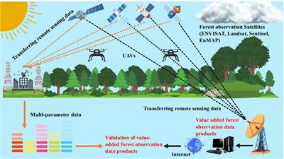
Amid the global challenges of forest degradation and climate change, the application of digital technology in forest resource management is increasingly recognized as an inevitable trend. The research by Do Cong Ba (Tan Trao University, Tuyen Quang province), published in the Proceedings of the 2nd National Scientific Conference on “Agricultural and Rural Environment and Sustainable Development,” focuses on analyzing the potential applications of artificial intelligence (AI) and remote sensing in forest monitoring. Agriculture & Environment Magazine is pleased to present this study to readers, providing an objective perspective on emerging approaches, from deforestation detection and wildfire prediction to supply chain transparency via blockchain, and exploring practical implementation prospects in Vietnam.

A research team at Nguyen Tat Thanh University has developed a method to convert water hyacinth, an invasive aquatic species, into activated carbon with the capacity to adsorb Tetracycline (TC)—a contaminant of emerging concern in aquatic environments. Experimental results showed that the activated carbon derived from water hyacinth exhibited a specific surface area of 630.46 m²·g⁻¹ and an adsorption capacity of 108.2 mg·g⁻¹, suggesting its applicability in wastewater treatment processes.
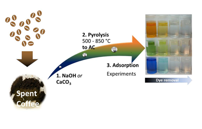
In the context of antibiotic residues in aquatic environments becoming a global concern, the search for effective, low-cost, and environmentally friendly treatment solutions is increasingly urgent. A Vietnamese research team from Nguyen Tat Thanh University, Ho Chi Minh City University of Natural Resources and Environment, the Institute of New Technology, and the Institute of Applied Research and Green Technology Transfer has introduced a novel approach: transforming spent coffee grounds into activated carbon with a high surface area, capable of removing up to 92% of tetracycline from water. The study not only addresses the challenge of antibiotic contamination but also illustrates the potential of circular economy practices in agricultural waste management.

Animal cloning is the process of producing genetically identical individuals without undergoing conventional fertilization. The successful creation of cloned animals has opened up numerous potential applications in basic research, medicine, and agriculture.

The Cai hoa vang glutinous rice variety is a well-known specialty of Thanh Hoa province, appreciated for its opaque white grains, characteristic aroma, and sticky texture when cooked—qualities that give it high economic value. However, after many years of traditional cultivation and informal seed exchange, the variety has shown signs of segregation and genetic degradation, resulting in unstable yields and inconsistent grain quality. This trend threatens not only production efficiency but also the preservation of an important local germplasm resource.