
Innovating the unmanned ecosystem: Realizing the spirit of Resolution No. 57/NQ-CP and the patriotic emulation movement
23/09/2025TN&MTAmid increasingly severe climate change and unpredictable natural disasters, the demand for accurate, continuously updated geospatial data to protect people and support socio-economic development has become urgent. In implementing the Government’s Resolution No. 57/NQ-CP on sustainable agriculture, environmental protection, and climate change response, our research team has adopted a science-driven approach closely linked to practical needs, measuring success by application effectiveness and prioritizing community service as the ultimate goal.
Innovation driven by real-life needs
Our distinction lies not in ideas on paper but in persistence: research – development – testing first, and only registering a project once safety and efficacy are ensured. This approach significantly shortens the timeline from concept to practical application, transforming initiatives into useful tools for production, management, and disaster mitigation.
Products such as GNSS–IMU-integrated UAV swarms, AGV–Survey vehicles, hydrological monitoring USVs, and mangrove reforestation robots all originate from real-world needs, are field-tested, and rapidly converted into domestic technological solutions for agriculture, environmental management, and irrigation systems.
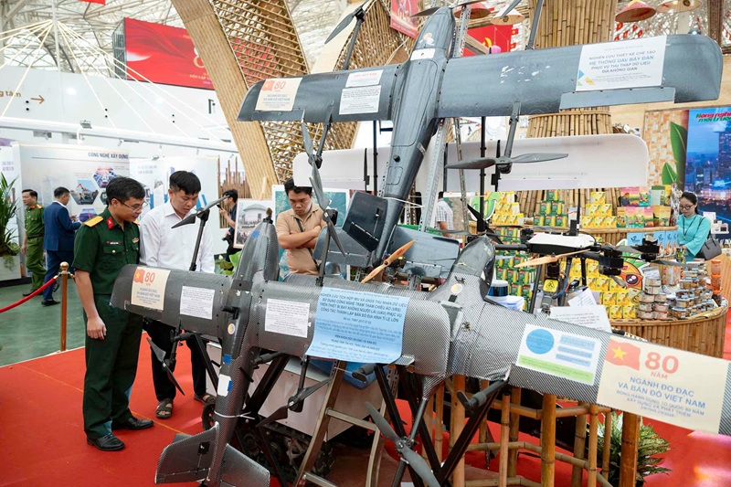
IMU–GNSS integrated research for data acquisition using Virtual Reference Station (VRS) technology on UAVs, supporting large-scale mapping, showcased at the Exhibition Celebrating 80 years of national achievements
Crucially, these projects are not developed merely for formality or reporting purposes. They address urgent societal challenges: (1) Farmers need tools to monitor crops accurately and in real time to minimize risks from pests, diseases, and natural disasters. (2) Local authorities require updated terrain and hydrological data to make informed decisions on relocation, flood prevention, and landslide mitigation. (3) The forestry sector seeks solutions for restoring mangrove forests, the ecological shield against storm surges and climate change. (4) The environmental sector requires continuous water and air quality monitoring systems, reducing reliance on imported equipment.
From these specific needs, we adopt a “bottom-up” innovation approach: starting from practical problems, addressing immediate issues, and then consolidating results into scientific contributions. Unlike the traditional model that moves from idea to project to product, this method reverses the sequence: small-scale testing, efficacy validation, then standardization into a research protocol. This ensures practicality, prevents projects from being shelved after approval, and accelerates integration into production and management.
Thus, innovation is not just a slogan; it is the close integration of science and daily life. Unmanned devices developed by Vietnamese scientists not only provide high productivity and precision but also exemplify a new paradigm: science must serve human needs while aligning with social responsibility and national security.
Realizing the spirit of Resolution No. 57/NQ-CP
Every research project and prototype device aligns with the objectives of the Resolution.
Sustainable agriculture: UAV swarms for crop monitoring, AGV land surveys, mangrove reforestation robots.
Environmental protection: USVs and ROVs for water quality monitoring, UAVs operating in tunnels for 3D mapping and pollution surveillance.
Climate change response: Real-time terrain and hydrological data for flood and landslide warnings, supporting safe relocation decisions.
These examples demonstrate that domestic science and technology can operationalize government resolutions through tangible actions and products. Beyond experimental deployment, unmanned devices have become an “extended arm” of Resolution 57/NQ-CP in practice:
Sustainable agriculture: UAV swarms have demonstrated precise crop monitoring capabilities, replacing dozens of manual survey teams. Farmers save time and costs while receiving early warnings on pests, yields, and soil moisture. AGV land surveyors supplement 3D data in lowlands, tunnels, or areas difficult for UAVs to access, completing datasets for modern agricultural planning. Mangrove reforestation robots have initiated breakthroughs in restoring coastal forests, serving as a “green shield” against erosion and storms.
Environmental protection: Domestic USVs and ROVs successfully measure depth, collect sediment samples, and monitor surface water quality, an important step in reducing dependence on imported equipment. UAVs operating in tunnels or GNSS-denied areas provide a new approach for 3D mapping and pollution monitoring in confined spaces such as mines, factories, and industrial zones.
Climate change response: The UAV–USV–AGV system delivers real-time topographic and hydrological data, providing early flood and landslide warnings and supporting safe evacuation decisions. For instance, during the Central Vietnam floods in 2020, UAV swarm technology reduced the time for producing 1:1000 scale maps from several weeks to just a few days, enabling timely rescue operations and resource allocation.
Each scientific device deployed in practice represents a “concrete version” of Resolution 57/NQ-CP, translating policy spirit into tangible tools that directly benefit people and society. Beyond enhancing productivity and data quality, these achievements affirm Vietnam’s innovation capacity, reduce reliance on imported technology, and strengthen national geospatial data security.
Outstanding benefits for surveying and mapping
UAV swarms replace dozens of GNSS survey teams in the field, reducing the timeline from weeks to days. They save manpower, ensure high accuracy, cover wide areas safely, and operate in challenging terrains such as mountains, forests, or flood zones. They are ideal for large-scale mapping, rapid disaster surveys, and both urban and rural planning.
AGV Survey & Mobile Mapping supplements 3D data in areas inaccessible to UAVs, such as dense urban centers, tunnels, or underground structures. Equipped with LiDAR, GNSS, and cameras, AGVs generate detailed 3D datasets, providing a comprehensive spatial picture essential for smart urban infrastructure planning, underground asset management, and heritage preservation.
USVs and ROVs expand measurement capabilities to rivers, lakes, and seas, previously heavily dependent on foreign devices. USVs can perform sonar-based depth measurements, hydrological monitoring, and water/sediment sampling, while ROVs survey deeper layers. This enables Vietnam to proactively manage reservoirs, ports, water resources, and aquatic environments.
The integration of UAV, AGV, USV, and ROV marks a historic shift for surveying and mapping. Previously labor-intensive, time-consuming, and high-risk, surveying has now transitioned to “automated measurement and digitization.”
This transformation brings at least three major benefits: (1) Superior efficiency: Survey time reduced from weeks to days, handling 3–5 times more work with significantly fewer personnel. (2) High-quality data: Modern sensors collect synchronized aerial, terrestrial, and underwater data, ensuring continuity, comprehensiveness, and real-time updates. (3) Safety and autonomy: Workers are freed from hazardous environments such as tunnels, flood zones, or offshore locations; Vietnam reduces reliance on imported technology, reinforcing national geospatial data security.
Thanks to these research initiatives, Vietnam’s surveying and mapping sector has entered the era of robotics and digital data, ready to meet the demands of smart planning, resource management, climate response, and sustainable development.
Achievements recorded
UAV swarms: GNSS–IMU–LiDAR–Camera integration, 1:1000 scale mapping, field-tested in mountainous, coastal, and flood-affected areas.
AGV Survey & Mobile Mapping: Vehicles integrated with LiDAR–GNSS–Camera, providing accurate 3D data supplementation.
USV–ROV: First domestic products for water monitoring, depth measurement, and sediment sampling.
Practical applications: From flood response in Central Vietnam 2020 to mangrove forest management, water environment monitoring, and search and rescue operations.
Vision for 2026–2030
Complete the UAV–AGV–USV–ROV ecosystem, integrating GIS–AI data for a Digital Twin.
Develop UAVs for tunnels and caves, 3D mapping, and pollution monitoring.
Deploy swarm robots for mangrove reforestation, restoring thousands of hectares of coastal forests.
Implement multi-beam sonar USV swarms, improving depth measurement efficiency 3–5 times.
Promote widespread application, establishing domestic surveying and monitoring services.
Policy orientation linking research with Resolution 57/NQ-CP and the patriotic emulation movement.
Patriotic emulation in science
The patriotic emulation movement extends beyond slogans; it embodies the spirit of daring to think, act, and take responsibility. Each UAV, USV, or robot deployed is evidence of Vietnam’s creative strength: using science as a tool and innovation as a driver.
The most commendable aspect is not the number of devices but their human-centered significance: freeing people from risks, reducing government burdens, saving social resources, and affirming a green, sustainable development path.
These studies convey a powerful message: science and technology are truly valuable only when they protect people and nature, placing human dignity at the center. This principle is at the core of Resolution 57/NQ-CP and represents the path Vietnam must steadfastly follow in the new era.
Luu Hai Au, MSc
Director, Center for Informatic Geodesy Cartography
(The Viet Nam Institute of Surveying and Mapping – Ministry of Agriculture and Environment)
Post Related
Promoting trade and investment between Vietnam and the state of Iowa

Coffee by-products: Unlocking new value from an overlooked resource

Science, technology, and innovation: The foundation for doubling productivity and increasing product value

Vietnam and Malaysia strengthen cooperation in agriculture, fisheries, and food security
Viet Nam promotes the role of communities in economic development linked with environmental protection
Partnering for a green future: The World Bank’s support for sustainable agriculture in Viet Nam

Vietnam’s agrifood momentum: Progress, partnerships, and a sustainable path forward
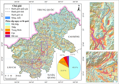
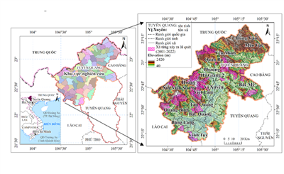
Decoding flash floods with GeoAI in Vietnam’s Northern Highlands - Part 2: Modelling extremes and what the maps reveal