
Application of artificial intelligence and remote sensing in forest monitoring: A new approach from Do Cong Ba’s research
23/09/2025TN&MTAmid the global challenges of forest degradation and climate change, the application of digital technology in forest resource management is increasingly recognized as an inevitable trend. The research by Do Cong Ba (Tan Trao University, Tuyen Quang province), published in the Proceedings of the 2nd National Scientific Conference on “Agricultural and Rural Environment and Sustainable Development,” focuses on analyzing the potential applications of artificial intelligence (AI) and remote sensing in forest monitoring. Agriculture & Environment Magazine is pleased to present this study to readers, providing an objective perspective on emerging approaches, from deforestation detection and wildfire prediction to supply chain transparency via blockchain, and exploring practical implementation prospects in Vietnam.
Forest monitoring in the digital era
Forests play a critical role in maintaining climate balance, conserving biodiversity, and providing valuable resources for human use. However, deforestation caused by illegal logging, wildfires, and the impacts of climate change has become an urgent global issue. Traditional monitoring methods, such as field surveys or ground-based sensors, are often costly, time-consuming, and limited in spatial coverage.
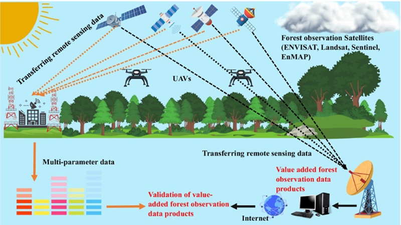
Application of remote sensing and AI technologies—combining satellite imagery, UAVs, and data analytics—for forest monitoring and sustainable management
Globally, countries including Canada, Brazil, and Indonesia have implemented AI- and remote-sensing-based forest monitoring systems to detect hotspots of wildfires, vegetation degradation, or illegal logging (Miller et al., 2020). In Vietnam, recent studies also indicate the potential of AI and remote sensing in forest resource monitoring. Specifically, Nguyen Thanh Phong et al. (2022) highlighted that remote sensing allows for more effective forest monitoring than traditional methods, while initial applications of AI support vegetation change detection. Similarly, Le Van Hung (2021) noted improved accuracy in detecting forest degradation using machine learning, especially in difficult-to-access areas. Although still at an experimental stage, these studies lay a crucial foundation for modernizing Vietnam’s forestry sector.
In this context, the application of digital technologies, particularly AI and remote sensing, offers a novel approach. The study emphasizes: “The development of artificial intelligence (AI) and remote sensing provides a breakthrough solution, enabling the automation of monitoring processes and delivering detailed real-time information on forest changes.”
Published in the Proceedings of the 2nd National Scientific Conference on “Agricultural and Rural Environment and Sustainable Development,” Do Cong Ba’s research focuses on the potential applications of AI and remote sensing in forest monitoring. The study sets out specific objectives: (1) Determine the role of remote sensing in tracking forest area fluctuations; (2) Analyze the potential of AI for detecting and forecasting forest degradation, wildfires, and illegal logging; (3) Evaluate the effectiveness of integrating UAVs and AI for data collection and processing; (4) Assess the potential of blockchain technology for enhancing transparency in timber supply chains and forest resource protection.
The author employed a literature review and analytical approach, drawing on diverse sources including domestic and international scientific papers, reports from international organizations (FAO, World Bank, WWF), and academic materials on AI, remote sensing, UAVs, and forest management. The content was classified into thematic groups (remote sensing, AI, UAV–blockchain integration, challenges and prospects), enabling a comparative assessment of strengths, limitations, and feasibility in the Vietnamese context.
Thus, the study not only provides a comprehensive overview of the potential of digital technologies in forest monitoring but also lays the groundwork for developing more effective resource management models aligned with sustainable development goals in the context of climate change.
Overview of AI and remote sensing applications in forest monitoring
Remote sensing is among the most important tools currently available for forest resource monitoring. This technology acquires information about the Earth’s surface through sensors mounted on satellites or aircraft, enabling observation without direct contact with the subject. The study emphasizes that remote sensing “provides high-resolution imagery, updated on a regular schedule, allowing the detection and monitoring of changes in forest area, vegetation cover, canopy structure, and human encroachment activities” (Brown et al., 2020; Zhang et al., 2022).
A notable advantage of this technology is its ability to cover wide areas and access difficult terrains such as tropical forests, high mountains, or rugged landscapes. Common satellites, including Landsat, Sentinel, and MODIS, can provide continuous datasets on weekly, monthly, and annual scales, supporting objective, long-term forest monitoring (Li et al., 2021). Additionally, integrating multiple sensor types, such as optical and radar imagery, improves accuracy, particularly in regions frequently affected by cloud cover (Nguyễn Trung Kiên, 2023).
Alongside remote sensing, AI increasingly demonstrates its role in processing and analyzing massive datasets. AI, particularly machine learning (ML) and deep learning (DL) methods, enables automated analysis and classification of thousands of satellite images, detecting subtle forest cover changes that are difficult for the human eye to perceive (Miller et al., 2020). The study notes that models such as Convolutional Neural Networks (CNNs) can classify land use, detect deforestation, wildfires, or ecological structure changes in forests.
Initial trials in Vietnam have shown significant potential. For instance, studies using AI to analyze remote sensing images for vegetation degradation detection (Le Van Hung, 2021) achieved high accuracy, suggesting the gradual replacement of manual monitoring methods with automated technology. When combined with climate, topographic, and supplementary datasets, AI can provide comprehensive analyses of forest changes, supporting forecasting and sustainable management efforts.
The complementary integration of remote sensing and AI creates a new approach: remote sensing delivers continuous, diverse, and comprehensive data, while AI undertakes deep analysis, trend recognition, and complex pattern detection. As the study concludes, this combination “allows forest management authorities to timely capture changes, optimize resource allocation, and respond rapidly to environmental threats.”
Practical applications of AI and remote sensing in forest monitoring
A key demonstration of AI and remote sensing value in forestry is their ability to detect and monitor forest degradation. Using high-resolution satellite imagery such as Sentinel-2 or Landsat 8, machine learning models can analyze vegetation cover changes over time, identifying hotspots of illegal logging or unusual ecological fluctuations. Algorithms including Random Forest, SVM, and CNN are widely applied to classify cover types and accurately locate deforested areas (Li et al., 2021).
The study cites international examples. In Brazil, the DETER-B system, developed by the National Institute for Space Research (INPE), applies deep learning to MODIS imagery to provide real-time deforestation alerts, reducing losses in the Amazon (Zhang et al., 2022). In Vietnam, Nguyễn Thanh Phong et al. (2022) experimented with Landsat images and machine learning algorithms to detect forest degradation, achieving over 85% accuracy. This represents a foundational step in localizing international technology for domestic use.
Beyond deforestation detection, AI plays an important role in wildfire prediction and early response. Wildfires pose major economic and environmental threats. Artificial Neural Networks (ANNs) and Long Short-Term Memory (LSTM) models have been applied to predict wildfire probability by region, based on meteorological and remote sensing data (Miller et al., 2020). Combined with UAV-mounted infrared sensors, AI can analyze thermal signals to detect hotspots and issue rapid warnings. In the United States, the Forest Watch system has reduced response times for wildfires in California by 30% using this approach (Fernandez et al., 2019).
Another application is monitoring forest and biodiversity recovery following exploitation or natural disasters. AI can analyze vegetation indices such as NDVI and EVI from satellite imagery to assess biomass recovery over time. Tran Minh Hoang (2019) tested UAV-integrated AI to monitor reforestation progress in special-use forests, demonstrating its effectiveness for adaptive restoration planning. In Indonesia, mangrove restoration programs have also applied drones and AI to assess canopy coverage after one to two years of replanting, optimizing resource allocation.
The study also highlights blockchain technology for timber supply chain transparency. Blockchain enables traceability from harvesting to market, preventing illegal trade. Chen et al. (2023) demonstrated its effectiveness in managing forest product supply chains in Southeast Asia. When integrated with AI and remote sensing, blockchain could support comprehensive, transparent, and sustainable forest management.
These practical applications indicate that AI and remote sensing are reshaping forest monitoring approaches. Their ability to handle large datasets, analyze in real time, and cover wide areas opens new prospects for resource management. The study emphasizes that “practical applications of AI and remote sensing, such as deforestation detection, wildfire forecasting, and ecological restoration monitoring, show substantial potential in supporting sustainable forest protection.”
Challenges in applying AI and remote sensing to forest monitoring
Despite the promise, real-world implementation faces significant technical, financial, and policy challenges.
First is the massive volume of data requiring processing. Satellites like Sentinel and MODIS can generate terabytes of data daily, necessitating high-performance computing infrastructure, optimized algorithms, and skilled technical personnel. In Vietnam, Pham Van Hung (2020) noted that satellite images in tropical forest regions are often cloud-covered or noisy, requiring multiple filtering techniques to ensure accuracy. Additionally, AI models need large, diverse training datasets; unstandardized or unrepresentative data may lead to biased analyses (Brown et al., 2020).
Second is the high initial investment. Developing a modern monitoring system requires substantial funding for satellites, UAVs, sensors, data storage, and analytical software. In developing countries, limited forestry budgets hinder access to advanced technologies. Johnson & White (2021) highlighted that many local agencies lack technical capacity to maintain and operate systems post-deployment.
Another challenge lies in input data quality and reliability. AI depends heavily on data sources, while remote sensing images may be affected by cloud cover, noise, or low resolution, making it difficult to detect subtle changes, such as small-scale logging. Li et al. (2021) warned that such errors could lead to misestimation of forest status. Wang et al. (2020) proposed combining CNN and LSTM models to improve detection from Sentinel-2 imagery, requiring highly synchronized and continuous data.
Finally, inadequate policies and specialized personnel remain bottlenecks. Many countries, especially developing ones, have yet to establish clear legal frameworks for AI integration in forest management. Fragmented data and inter-ministerial sharing mechanisms reduce technology application efficiency. Nguyen Thanh Phong et al. (2022) also noted that most current forestry staff lack training in data science, machine learning, or remote sensing analysis. This underscores the need for interdisciplinary training programs integrating forestry, information technology, and data science.
Thus, despite technological readiness, applying AI and remote sensing in forest monitoring heavily depends on technical infrastructure, human resources, and institutional support, critical factors for converting potential into practical outcomes.
Prospects and development directions
Rapid advancements in AI and remote sensing open numerous opportunities for forest monitoring at national, regional, and global scales. Under increasing pressures from climate change and resource exploitation, integrating digital technologies into forest management is considered an inevitable trend.
An important direction is developing AI models specialized for specific ecological regions. According to Zhang et al. (2022), self-learning models adapted to local data can improve detection accuracy for forest degradation, wildfires, or vegetation regrowth. Combining remote sensing data with microclimate, soil type, and topographic information enriches training datasets, enhancing predictive performance. International projects are increasingly providing open datasets for the scientific community and local authorities, enabling developing countries to adapt and utilize technologies more effectively.
Another prospect is building integrated monitoring systems combining multiple technologies. The study highlights that future forest monitoring will extend beyond satellite imagery to include UAVs, IoT sensors, blockchain, and AI-based big data platforms. Miller et al. (2020) and Chen et al. (2023) emphasize that such integration allows for proactive monitoring, early warning, and timely decision support.
Moreover, supportive policies and multi-sector collaboration are prerequisites for realizing technological applications. Johnson & White (2021) stress the importance of establishing legal frameworks for using remote sensing and AI in forest monitoring, national standards for digital forestry data, and financial mechanisms to support technological infrastructure investments at local levels. Regarding human resources, training programs must be designed interdisciplinary, combining forestry knowledge, information technology, and environmental policy expertise.
For Vietnam, this presents an opportunity to align with global digital transformation trends in resource management. With strategic investment and cross-sector coordination, Vietnam could develop smart forest monitoring models at provincial or ecological-region scales, significantly contributing to sustainable forestry and climate adaptation. As the study concludes: “Applying artificial intelligence (AI) and remote sensing in forest monitoring is not only a technological solution but also a core component of digital transformation in forestry, critically supporting effective forest management and sustainable development.”
The application of AI and remote sensing opens modern, more efficient approaches to forest monitoring. Remote sensing provides continuous spatial and temporal data, while AI enables analysis, recognition, and forecasting, supporting resource management. Applications such as deforestation detection, wildfire prediction, and ecological restoration monitoring demonstrate significant potential; however, effectiveness requires synchronization of technology, data, cost, policy, and workforce. In Vietnam, long-term strategies, infrastructure investment, and cross-sector coordination are essential. Amid climate change and resource degradation, AI and remote sensing are not only technological solutions but also core elements in digitalizing forestry, contributing to sustainable forest protection./.
Ngoc Huyen
Source: Proceedings of the 2nd National Scientific Conference on “Agricultural and Rural Environment and Sustainable Development.
Post Related

Promoting trade and investment between Vietnam and the state of Iowa

Coffee by-products: Unlocking new value from an overlooked resource

Science, technology, and innovation: The foundation for doubling productivity and increasing product value

Vietnam and Malaysia strengthen cooperation in agriculture, fisheries, and food security

Viet Nam promotes the role of communities in economic development linked with environmental protection
Partnering for a green future: The World Bank’s support for sustainable agriculture in Viet Nam

Vietnam’s agrifood momentum: Progress, partnerships, and a sustainable path forward
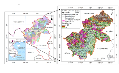
Decoding flash floods with GeoAI in Vietnam’s Northern Highlands - Part 2: Modelling extremes and what the maps reveal